BANGKOK Subway BTS MAP HD 1.0
Free Version
Publisher Description
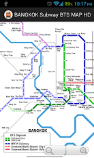
SystemThe present Bangkok mass transit system comprises two different types of metros: 1) the elevated BTS system, the so-called Skytrain - rot fai fah in Thai, and 2) the underground MRT subway. Although BTS and MRT use similar technology (trains, signalling & train control), there is no track connection between them. All MRT stations are equipped with platform-screen-doors, which does not apply to any BTS station.Besides the mass transit rail systems, Water Buses provide a fast transport service on the Chao Phraya River; at present, transfer to the BTS system is only possible at Saphan Taksin station. Green Lines (BTS-Skytrain) This is a completely elevated system built by Siemens as a turnkey project, opened in 1999, initially 23 km long with 23 stations. The BTS system consists of two lines: the Sukhumvit Line (22 km) and the Silom Line (8.5 km).Track gauge is 1435 mm and power supply is via third rail at 750 V DC. 3-car trains are 65 m long (a fourth car being added to all trains between 2012 and 2013), air-conditioned and run at an average speed of 35 kph. Saphan Taksin station on the Silom Line was only planned as a temporary station, but as it offers an excellent connection to the Water Buses on Chao Phraya River, it remains open after the extension to Wongwian Yai, although the single-track section at Saphan Taksin station limits the capacity on the Silom Line. The elevated Green Line depot is connected to Mo Chit station.05 Dec 1999: basic BTS network - Sukhumvit Line Mo Chit - On Nut- Silom Line National Stadium - Saphan Taksin15 May 2009: Silom Line Saphan Taksin - Wong Wian Yai12 Aug 2011: Sukhumvit Line On Nut - Bearing (5.25 km)12 Jan 2013: Silom Line Wong Wian Yai - Pho Nimit 14 Feb 2013: Silom Line Pho Nimit - Talat PhluBlue Line (MRTA) In August 1997 construction work began on this 21 km underground full metro with 18 stations; it finally opened for trial service in April 2004. In December 2001, Siemens was awarded the contract to build 19 three-car trains for this line and to provide the necessary operating equipment.A 1-station extension from Bang Sue to Tao Pun is planned to create an interchange with the future Purple Line; the Blue Line would be on surface at Tao Pun station.The standard Blue Line station has an island platform on level -3. Sam Yan, Silom and Lumphini stations have side platforms on different levels, each with trains to Bang Sue on level -2, and trains to Hua Lamphong on level -4, whereas Bang Sue and Khlong Toei stations have two side platforms on the same level. Thailand Cultural Centre is much bigger than other comparable stations: the Blue Line stops on level -3, while level -2 is prepared to accommodate the Orange Line in the future. The surface Blue Line depot is connected directly to both Thailand Cultural Centre and Phra Ram 9 stations. A track connection between Blue and Orange Lines will be made via this depot.City Line & Airport Rail Link 28 km elevated line with 8 stations, standard gauge, from Phrayat Thai via Makkasan/City-Terminal to Suvarnabhumi Airport), every 15 minutes, shared with special non-stop airport express which departs from Makkasan/City-Terminal, opened for commercial operation on 23 August 2010.23 Aug 2010 - City Line & Airport Rail Link
About BANGKOK Subway BTS MAP HD
BANGKOK Subway BTS MAP HD is a free app for Android published in the Other list of apps, part of Home & Hobby.
The company that develops BANGKOK Subway BTS MAP HD is iMap Place. The latest version released by its developer is 1.0. This app was rated by 1 users of our site and has an average rating of 4.0.
To install BANGKOK Subway BTS MAP HD on your Android device, just click the green Continue To App button above to start the installation process. The app is listed on our website since 2013-05-27 and was downloaded 138 times. We have already checked if the download link is safe, however for your own protection we recommend that you scan the downloaded app with your antivirus. Your antivirus may detect the BANGKOK Subway BTS MAP HD as malware as malware if the download link to com.red.bangkok is broken.
How to install BANGKOK Subway BTS MAP HD on your Android device:
- Click on the Continue To App button on our website. This will redirect you to Google Play.
- Once the BANGKOK Subway BTS MAP HD is shown in the Google Play listing of your Android device, you can start its download and installation. Tap on the Install button located below the search bar and to the right of the app icon.
- A pop-up window with the permissions required by BANGKOK Subway BTS MAP HD will be shown. Click on Accept to continue the process.
- BANGKOK Subway BTS MAP HD will be downloaded onto your device, displaying a progress. Once the download completes, the installation will start and you'll get a notification after the installation is finished.
